Daily Reports from the Silk Road......
Return to About or The Route in Detail To get in touch try Contact Tony
Friday 27th October - the end of our epic Adventure!
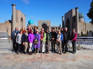
My intrepid travel companions!!
Getting up latish on Friday morning it was difficult to believe our adventure had come to an end.... we had journeyed together for 47 days and visited 27 Cities in six countries! Now we were about to scatter, literally, to the four corners of the earth. A journey like that simply cannot be summarised, so i won't attempt it.
But I will play tribute to the 15 intrepid travellers with whom i made the trip - knowledgeable, experienced, humorous, endlessly patient, all of whom i will remember for a long time with great fondness. And of course big respect to Jude Holliday our Tour Leader who gently cajoled, encouraged, injected a dash of sympathy where required and some sterner stuff when rarely needed. I never once heard her say: 'this is adventure travel, so stop whingeing' which is mainly a further tribute to my fellow travellers!! Good game, Jude!
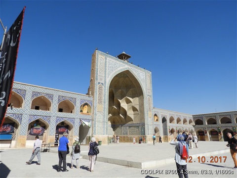
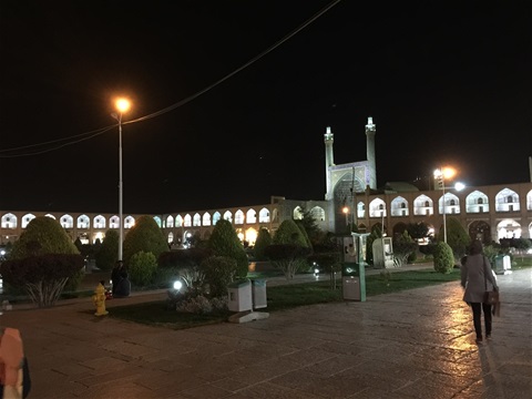
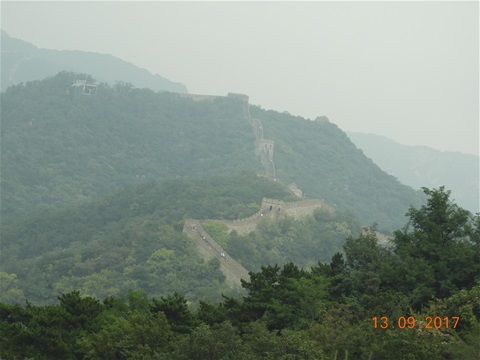
Thursday 26th October - Istanbul in all its glory
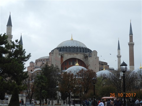
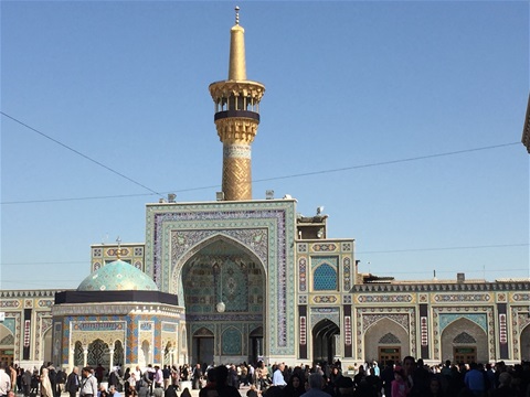
The Sultan Ahmed Mosque in Istanbul
So, we had pretty much a single day to take in as much as we could of Istanbul - Turkey's most visited tourist destination! We spent our time looking the the Sultan Ahmed Mosque, also known as The Blue Mosque, the absolutely unique Hagia Sophia Museum and the Hippodrome - location of Chariot races and other Roman sports of the Eastern Empire. I also managed a trip to the Grand Bazaar to do a little last minute shopping.....
Here are some links to the pics:
Wednesday 25th October - from Ankara to Istanbul
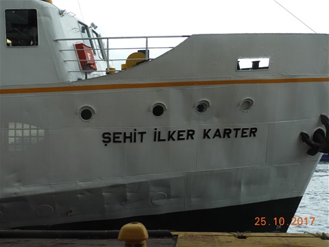
Our ferry across the Bophorus
Up early today for the final leg of our epic journey - we travel from Ankara the modern capital of Turkey to its ancient capital Istanbul. Talk about multi modal travel - we take a minibus ride to the railway station in Ankara, a fast train from Ankara to a station 20 miles east of Istanbul, jump on a coach to take us to the ferry terminal, ferrry across the Bophorus from Asia to Europe, Istanbul tram to within a couple of hundred yards of our hotel, then shanks pony for the last little bit!!
Quick shower then out to dinner at a roof top restuarant withing walking distance of the hotel, just as well as we had only our third day of rain since leaving Beijing 45 days previously!!
You can find the pics from our journey here: Ankara to Istanbul
Tuesday 24th October - Ankara: Ataturk Mausoleum, Ankara Castle and The famous Museum of Anatolian Civilisations
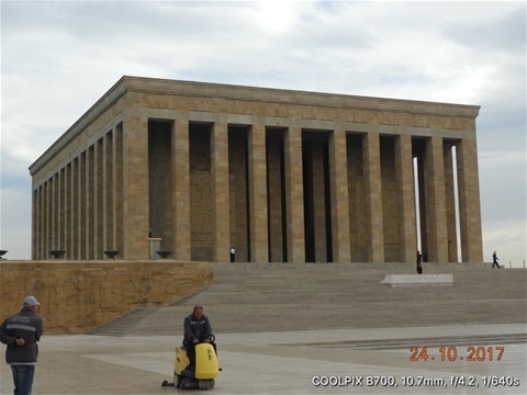
Kemal Ataturk Mausoleum
Ankara is a relatively new city having gone from a population of maybe 20,000 at the beginning of the Republic of Turkey to several millions today. Despite this we still had an extraordinarily busy day in the city, visiting the Kemal Ataturk Mausoleum and Museum, Ankara Castle and the famously Museum of Anatolian Civilisations. Generally Ankara is not regarded as a high profile tourist destination but we could have kept interested and busy for a couple of days at least!!
See pics of these three great venues here:
Monday 23rd October - The Hittite Kingdom and onward to Ankara
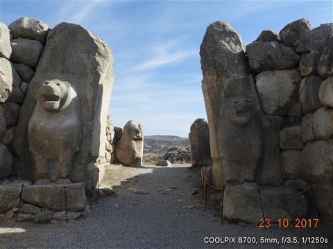
The Lion Gate: main entrance to the Hittite Kingdom
We managed 240 miles on the bus today, from Amasya to Ankara via the immense Hittite Fortress at Hattusa.
The scenery on our journey was not as spectacular as the previous couple of days, but always interesting and rarely below 3,000 feet.
The Hittites were an ancient Anatolian people who in around 1600 BC established an empire centred around the Empire's capital at Hattusa in north Central Anatolia, mid way between Amasya and Ankara. The empire reached its height in the mid 14th Century BC, but came into conflict with the Egyptian and Middle Assyrian Empires and the the empire of the Mitanni. After about 1180 BC the Hittites were overcome by the Assyrians and the Phrygians.
There are three main elements to the site:
1. The original Hittite imperial city, Hattus, consisting of an Inner City and an Outer City, both surrounded by a massive course of walls, still visible 3,500 years later.
2. Yazilikaya, which was a sanctuary located within walking distance of the gates of the city of Hattusa. This was formed of two main roofless chambers, formed inside a group of rocky outcrops.
3. A more modest Phrygian settlement, built by them on the same site as Hattusa around 800 BC.
Easily the most important archaeological find on the site were the 30,000 cuniform royal archives of clay tablets consisting of official correspondence and contracts as well as legal codes, procedures for cult ceremonies and so forth. One particularly important tablet details the terms of the peace treaty reached years after the Battle of Kadesh between the Hitties and the Eqyptians under Rameses II in about 1258 BC. A copy is on display in the United Nations in NYC as an example of the earliest known international peace treaties.
Have a look at more pics of the 3500 year old Hittite Kingdom at Hattusa here:
Sunday 22nd October - Amasya: a charming and relaxed city
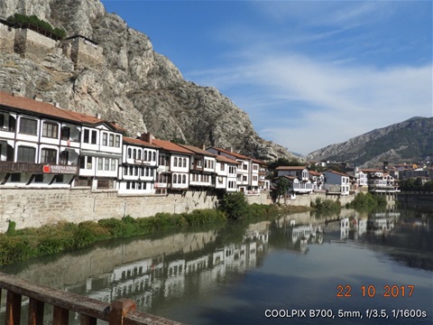
Beautifully restored Ottoman houses along the banks of the river In Amasya.
This was probably one of our most relaxed days since the start of the tour. However, no rest for the enthusiastic saw us clambering up to the top of Amasya Castle!
Although Amasya is located in what is a conservative area of Central/Eastern Anatolia tourism seems to have brought a more relaxed and easy going vibe to the City. We enjoyed a great al fresco lunch down by the river before most of us headed off to the local market....
See more pics of this charming and relaxed city here:
Saturday 21st October - The lovely City of Sivas and on to Amasya
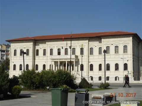
After an early breakfast we had a splendid morning in Sivas, the former Seljuk capital of Turkey during Ottoman times. The city is beautifully laid out and has a relaxed atmosphere about it. Lots of street cafes with folks sitting quietly sipping the lovely Turkish coffee which i have promised myself i will learn to make when i get home!
We then spent three hours driving on to the even more relaxed city of Amasya... Countryside less dramatic than further east on the Anatolian Plateau, but still starting at around 4,000 feet in Sivas before descending steadily to about 1,500 feet in Amasya. Steadily more fertile as we moved west, more and more evidence of all available agricultural land being cultivated more intensely. A satisfying and stimulating drive....
You will find lots of pics of Sivas here: Sivas
Friday 20th October - Another terrific drive: to Sivas
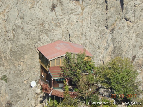
We called this house ‘The Eagle’s Nest’ perched as it was on an impossibly pointed spike of rock
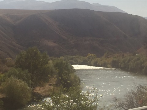
I am running out of superlatives really about this Anatolian Plateau scenery, each day we imagine we have seen the best of it, then the next proves even more dramatic! So it was today as we drove north until we crossed the Western Euphrates at Bagistas and then turned west towards Sivas.
We also had a couple of interesting stops today. We were privileged to visit the village of Onar to see a place of worship of the Alevi Islamic sect. Alevis don't have mosques, but pray in private houses adapted for their religious purposes. The one we visited had a couple of trees growing from the floor and through the roof which worshippers hugged at an appropriate stage in the proceedings. Never having felt the need to hug trees myself i desisted but a couple of our number did join in.... We also enjoyed a largely vegetarian lunch in a restaurant in the nearby town of Arapgir run - as i understood it - by a ladies cooperative who speciality seem to be a delicious desert cooked in an enormous copper tub!
You will find more pics of the astonishing Anatolian scenery we saw and few pics of the Alevi place of worship and the town of Yurkseverhere: The stunning drive to Sivas
Thursday 19th October - A stunning drive along the Euphrates to Kemaliye
The Euphrates River valley slicing through the Anatolian Plateau..
Any trepidation about another long five hour drive from Eruzum to Kemaliye was soon eradicated by the glorious, dramatic scenery along our route! A look at the pics will hopefully give you some idea of what we sawe: Across the Anatolian Plateau to Kemaliye
Kemaliye is a small town with a population of less than 5,000 but with a huge name, having in 1922 been renamed from Egin to honour Mustapha Kemal Pasha as he was then known. I cannot tell you why the small town was honoured in this way....
The place is located in a gorge in the Euphrates River valley just above the Keban Dam. The streets are very steep and cobbled, most of them pretty much like stairways! The town itself is at about 3,700 feet, but the mountains on either side of the gorge soar another 4,000 feet above the town. It's a truly dramatic location.
Wednesday 18th October - Across the Anatolian Plateau to Erzurum
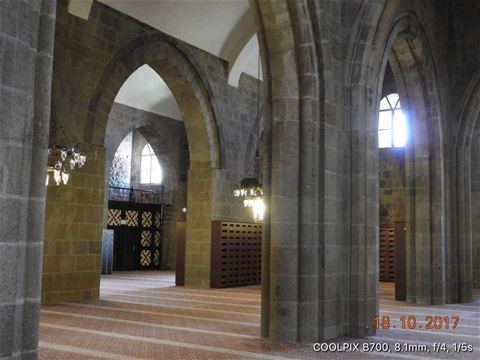
Interior of the Great Mosque of Erzurum aka Ulu Camii
Our journey across the Anatolian Plateau from Kars to Erzurum was interesting rather than spectacular but as we were to learn in the following days on our journey right across Northern Turkey from the Iranian border to Istanbul would soon become very dramatic indeed!
On our way we came across a war memorial dedicated to one of the greatest disasters to befall the Ottoman Empire during WW1: the Battle of Sarıkamış. This took place between the Ottoman Empire and the Russian Imperial Army in December 1914 And January 1915. Basically the ill-prepared Ottomans made the same mistake asNapoleon had before them and Hitler would make in WW2: taking on the Russian Army in the middle of winter without securing their supply lines. The ill-fated Ottoman troops tried to fight in summer uniforms, poorly fed and badly armed: the ships with their supplies were sunk in the harbour at Trabzom on the Black Sea. It is estimated that 33,000 Ottoman troops died, many of hypothermia while a further 17,000 were wounded or captured. The Ottoman leader Enver Pasha blamed the defeat on the Armenians fighting with the Russians and many believe this was a prelude to the Armenian massacres that followed not long after.
You will find more pics of Erzurum here: The City of Erzurum
Tuesday 17th October - Kars and the astounding Ani
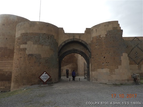
The main entrance through the Ani City wall
Ani is a ruined medieval Amenian City which somehow found itself just on the Turkish side of the now closed border between the two countries when the borders of the newly formed Republic of Turkey were drawn in October 1923 and is about 30 miles west of our base in Kars. Until recently Ani was completely inaccessible because it is located in an area that had been designated a closed military area by hthe Turks. There are still a couple of signs to that effect on the site. As you can imagine the site has been the subject of great contention between the two governments, the bottom line is that it has been very badly neglected with rumours of the Turkish Army using it for artillery target practice.
Fortunately those days are now past and in 2016 it was designated a UN World Heritage Site. The Turks have said that protecting and retoring the site is a priority for them, but I have to say we did not see a great deal of evidence to support that during our visit. As you will see from the pics, some basic work has been done to prevent further deterioration but there is also evidence of much crude restoration over many decades.
The city was founded in the 5th century AD and in the 10th C it became the capital of the Bagratid Armenian kingdom that covered much of present day Armenia and Eastern Turkey. Ani was situated on many important trade routes, not least the Silk Road, had many Palaces and Churches and at its height had a population of around 100,000.
You can find out more about Ani here: Ani
It really is an astonishing site and well worth checking out on Wikipedia if you find it as interesting as I do!!!
Monday 16th October - onward to Kars
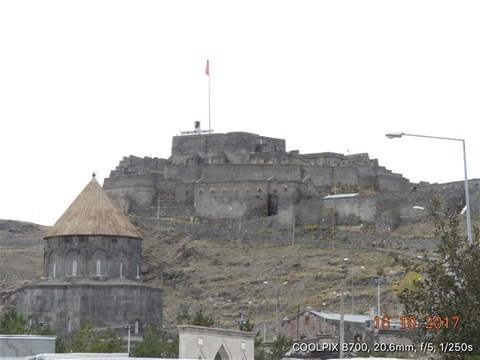
Kars Castle - British troops were besieged hereduring the Crimean War
The drive from Dogubayazit to Kars was interesting rather than exciting, but constantly dominated by views of Turkey’s highest mountain Mount Ararat of Noah’s Ark fame. We were also intrigued to be driving alongside Turkey’s border with Armenia which has been closed since 1993, initially as a consequence of the war over Nagorno-Karabakh and more recently due to the disagreement between Armenia and Turkey as to whether the Turk expulsion of Armenians during WW1 constituted a genocide.
This part of Turkey is deeply conservative - many restaurants do not sell alcohol for example and many of the Turkish ladies wear headscarves - and is rarely visited by tourists. However, locals were invariably friendly and always curious about who we were and where we came from. Lots of us - especially the ladies in our party - were frequently called upon to provide selfies with our hosts!!
You will find more pics of Kars here: Kars
Sunday 15th October - A tricky border crossing and the Ishak Pasha Palace
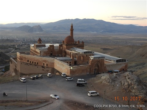
The Ishak Pasha Palace
So, our fifth and final border crossing all seemed very straightforward: getting out of Iran went smoothly but getting everybody into Turkey proved a bit more challenging. First were the cigarette smugglers - fags are dirt cheap in Iran and very expensive in Turkey. What shook us was the blatant nature of what was happening and what looked to us like the open connivance of some of the Turkish border officials! This smuggling impacted on our crossing in two ways: first all of us were accosted pretty aggressively to carry fags through customs on behalf of the smugglers and secondly they used a kind of ‘steaming’ tactic to rush the border and get as much contraband through as they could! This of course created chaos and some unpleasantness..... The second source of delay was that our two US Citizens in the party found themselves held up for several hours while the local officials got permission from Ankara to let them into Turkey. The fact that all this was happening on a Sunday, certainly did not help. As frequently happens what was needed was patience and good humour and in due course we were all reunited!!
The majority of us headed off to visit the Ishak Pasha Palace which overlooks Dogubayazit about which you will find more here:
Saturday 14th October - Tabriz and the Blue Mosque
The Blue Mosque in Tabriz
We had a long day on Friday with an early start and got into our hotel pretty late that evening, so we were allowed an extra half hour in bed before starting a busy day in Tabriz on Saturday!
In addition to a visit to the famous and important Blue Mosque we had some adventures in Tabriz’s gigantic Bazaar. This was very different to the more touristy offerings in some of the other Silk Road city which is part of the reason it provided an excellent opportunity for some serious people watching! The Bazaar allegedly stretches over 9 km Andy has 22 domed halls. Tabriz is famed for its carpet making industry and so inevitably many of its ‘shops’ are outlets for the hundreds and hundreds of carpet merchants. There are some pics of the Bazaar in the Pics of Iran section. You will also find there some pics of our other adventure in which we took tea with a bunch of Armenian/Iranian old gentlemen puffing on hookah pipes!!
The Blue Mosque lived up to its billing and you will find more information about that and some more pics here: Blue Mosque Tabriz
Friday 13th October - flying back to Tehran and on to Tabriz
Tehran is almost surrounded by mountains....
Up at four this morning to catch the first flight out of Isfahan back to Tehran on our way to Tabriz in the far northwest of Iran. Tabriz is our final port of call in Iran before heading over the border to Turkey on Sunday.
This itinerary gave us an extra few hours in Iran a couple of which were spent at the Reza Abbasi Museum. THe Museum was opened a year before the Revolution and shows the vast collection of ancient artifacts and medieval art and calligraphy collected by the wife of the last Shah of Persia. In addition to the few thousand exhibits on display we were told that a further 50,000 collected by the Empress Farah are kept in storage.
Tehran has a legendary pollution problem caused partly by the dramatic increase in the number of vehicles on the roads over the last decade, fuelled by the fact that it costs four euro for a tank of petrol! The whole problem is exacerbated by Tehran’s geography: the city is surrounded by mountains which leave it in a wind shadow which allows the pollution to build up!
Some assorted pics of Iran here: Pics Iran
Thursday October 12th - Isfahan: The Jameh Mosque and New Julfa
One of the stunning gates in the Jameh Mosque
The city of Isfahan was one of my favourites in Iran with the vast Naqsh-e Jahan Square, the Grand Bazaar and what proved to be one of the lovliest hotels on our journey. There are also a couple of elegant and beautifully lit bridges over the once mighty Zayandeh River. I say 'once mighty' because as has often happened in this part of the world [The Aral Sea is the most notorious example] over ambitious attempts to irrigate the desert have resulted in disaster. In the case of the Zayandeh River it was completely dry when we visited, although i understand that in some seasons it does have a small flow of water.
New Julfa is the Armenian Quarter of Isfahan, located along the south bank Zayandeh River. It was established in 1606 as an Armenian Quarter by the edict of Shah Abbas 1 from the Safavid Dynasty and was named after the Armenian city of Julfa, Nakhichavan. New Julfa remains one of the world’s largest ethnic Armenian Quarters with an Armenian School, sixteen churches and the Holy Saviour Cathedral.
The Jameh Mosque in Isfahan is regarded by many scholars as the oldest surviving Mosque in Iran, aside from which it is also the grand congregational Mosque for the City of Isfahan.
See more pics of the Jameh Mosque Isfahan and New Julfa
Wednesday 11th October - Naqsh-e Jahan Square Esfahan
The Naqsh-e Jahan Square in Isfahan at night
Cheating a little here because this pic was taken on Tuesday evening on our way out to dinner not long after we had arrived in Isfahan! However, we then spent all Wednesday morning checking out the Square and the three main buildings that form part of the complex: the Ali Qapu Palace, the Sheikh Lotf Allah Mosque and the Shah Mosque
The whole Square is almost one million square feet so you will enjoy the pics here: Naqsh-e Jahan Square
Tuesday 10th October - long drive to Isfahan via Fin Gardens at Kashan
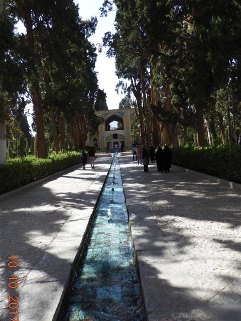
The Fin Gardens at Kashan
We knew we were in for a long drive across the Iranian desert, south to Isfahan but with the stop at Kashan to see the Fin Gardens and the tantalising prospect of spending time in Isone of Iran’s most beautiful cities, plus the fact we would get three nights in the same hotel made the whole prospect much brighter!
We passed the Khomeni Mausoleum on the way out of Tehran but did not bother to stop.... As we left the City behind the sheer rugged toughness of the Iranian desert began to unfold- no cultivation, no grazing just scrubby desert with lots of broken rock and vicious looking sharp and corrugated ridges which must have made life exceptionally difficult for Silk Road traders. We saw a huge apparently shallow lake off to the west, looked saline to me but no way of knowing for sure. The desert was slightly less severe as we reached the region around Qom - a little grazing, sheep and camels, but very little arable. Kashan of course and the Gardens of Fin in particular were a welcome oasis and we enjoyed a Vegetarian lunch in a beautiful restaurant set slightly below ground to help ward off the desert heat.
More pics of the Fin Garden
Onward then to Isfahan and our legendarily beautiful 300 year old Hotel Abbasi and a quick stroll around the delightfully lit Naqsh-e Jahan Square on our way to dinner at a traditional Iranian restaurant complete with day beds to eat on and kebabs to consume!
Monday 9th October - Tehran: The Golestan Palace and the Iranian Crown Jewels
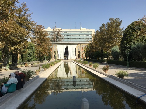
Serene Pond looking down towards the Marble Throne near the Golestan Palace
Given the tumultuous 20th Century background to Iran and the current political situation it is easy to lose sight of the awesome history of Iran and Persia and the contribution the country has made to civilisation over the centuries. Against that sweep of history Tehran itself is a relatively modern city having been founded in the sixteenth century and chosen as the country’s capital in 1795 by Agha Mohammad Khan of the Qajar Dynasty.
Sadly the IR of Iran bans photography in two of the major legacies of modern Iranian history: the Golestan Palace and the Iranian Crown Jewels collection, so you will have to take my word for it and my inadequate descriptions to try to appreciate the stunning nature of what we saw!
The Golestan Palace started unpromisingly with what seemed to me a largely nondescript set of buildings not always well restored but set in lovely quiet parks well away from the cacophony of Tehran’s legendary traffic. Almost all the buildings were constructed by the Qajar Dynasty during the late 18th Century and rebuilt in its current form in 1865. Between 1925 and 1945 a large proportion of the buildings in the complex were destroyed by Reza Shah who believed that Tehran’s development as a modern city should not be hampered by a bunch of old buildings!! Once we got inside it became clear that the Palace is primarily about the magical interior decoration of the place and the astonishing collection of treasures and furnishings being mainly four centuries of gifts from foreign potentiates to the Qajar Dynasty and the Pahlavi era.
More pics of the Golestan Palace
Sunday October 8th - Marshhad and the Imam Raza Complex
The Holy Shrine of Imam Reza
Ali Ibn Musa al-Reza was the eighth Imam of the Twelver branch of Shi'ite Islam. He was born in Medina on 6th January 766 and live under the reign of three Abbasid Caliphs. The last of these Ma'mun so feared Imam Reza and his popularity amongst the faithful that he martyred the Imam on 9th September 818.
His shrine is one of the holiest in Shi'ite Islam and the complex covers almost six and half million square feet and contains the Goharshad Mosque, a museum, a library, four madrassas, a cemetery, the Razavi University of Islamic Sciences, a dining hall for pilgrims, vast prayer halls and other buildings as well as sanctuaries, enormous courtyards and porches. The complex is widely regarded as one of the finest examples of the history of Iranian-Islamic art and civilization.
See some more pics of the huge Imam Reza Complex
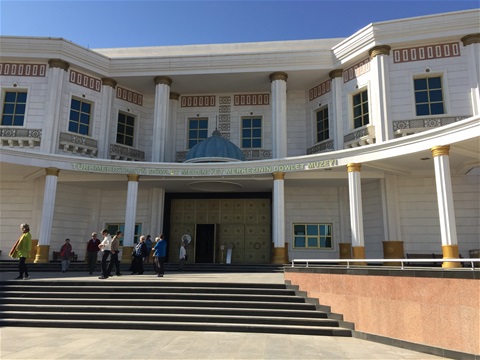
Saturday 7th October - Ashkabat's surprising National Museum and crossing into Iran
Entrance to The National Museum in Ashkabat
We had showed up at the Turkmenistan National Museum in Ashgabat on Friday, only to find out it was closed owing to some national holiday. We were promised that if we came back first thing this morning, then we would be able to get it. And so it was.... not only that we had a personal tour of the Museum by clearly a senior guy who had fluent English, excellent knowledge of his subject and willingness to engage in a conversation about the exhibits and their history. What was not allowed was photography.... which was real shame, the whole thing was beautifully laid out with some wonderful exhibits and lots of information about each exhibit in English. Yes, the ground floor was full of pictures of the President and exhibits showing the wonder of his works but interestingly our guide skipped that altogether! Yes, some of the wording on the descriptions of the exhibts might be regarded as jingoistic, but generally we all thought it was a high quality museum. We had not been expecting that, given the Museum building is another one of the marble edifices we had already seen far too much of! I am only sorry i cannot share with you more about the exhibits.....
With a fair measure of excitement, we then set off for the border crossing from Turkmenistan into Iran. The two US citizens in our party just a little more tense perhaps than the rest of us....
Compared to some of our previous border crossing experiences this was a piece of cake! Getting out of Turkmenistan required a little patience but all was well in the end, we having had to put up with more statues and pictures of the President. Getting into Iran did involve sitting around for about 90 minutes, [but chairs were provided!] and our two US citizens were interviewed as to why they wanted to enter Iran, but they reported back that process was brief and courteous. Next thing we knew, we were in Iran!!
Pics of our journey: From Turkenistan into Iran
Friday 6th October - 3rd Century BC Parthian Fortress
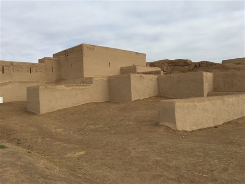
3rd Century BC Parthian Fortress
We had our dinner last night on the top floor of a posh, marble clad, 18 storey empty hotel in Ashgabat. At night we immediately saw why many people see similarities between Ashgabat and Las Vegas: both are in the middle of a desert and both are obsessed with marble clad buildings and the pervasive use of glaring neon strips on all the buildings. I have put a few pics After dark in Ashgabat... so that you can get some idea!
The Parthian Fort had been a real treat after the weirdness of Ashgabat, but after that we had one more turn around the city to have a look at some of the marble clad monstrosities and golden statues of the president that we might have missed previously. You're right, i don't much like Ashgabat and specifically left the place seething at the grinding poverty and oppression of so many of its citizens when the politicians are lining their pockets and indulging themselves in medieval fantasies... rant over!
Next stop was visit to a farm breeding Heavenly Horses... some pics here: Heavenly Horses
Learn more about and see pics of 3rd century BC Parthian Fort
Thursday 5th October - a short flight across the desert to Ashgabat
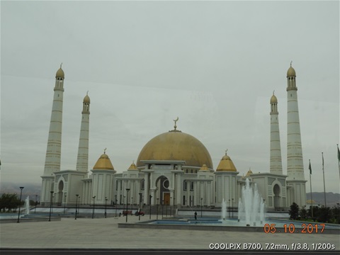
Turkmanbashi Ruhy or Gypjak Mosque, Ashkabad
Superficially, you could not imagine two worlds more different than Ancient Merv and Ashkabat. Astonished visitors to the latter often make comparisons with Disneyworld in the physical sense of a series of vast white marble monstrosities a la Cinderella's Castle and of a fantasy world designed by and for children with no expense spared and without allowing taste or style to interfere with the imaginings. My own view is that it has a sense of Portmerion (N Wales) about it, although on an unimaginably more grandiose scale.
The place pretty much started again from scratch following the tragic earthquake in 1948 which destroyed the city and killed between 110,000 and 176,000 people (the uncertainty arises because the Soviets never gave a proper number - their official toll was 40,000). In more recent times it has become a showcase for the accomplishments of the young Republic of Turkmenistan which became independent in 1991 following the demise of the USSR.
I used the word 'superficially' at the beginning because there is no doubt in my mind that the first President of the newly independent Turkmenistan Saparmirat Niyazov, who styled himself Turkmanbashi did see himself as spiritual successor to Sultan Sanjar and the other great Seljuk leaders who are buried at Merv and ruled at a time when according to one renowned historian the city had a population of 200,000 and was said to be the largest in the world. I feel had you visited as I did Sultan Sanjar's Mausoleum at Merv one day and Turkenbashi's Mausoleum at Ashgabat the next you would have been left with the same impression!
Have a look at some of the pics here Ashgabat and see what you think!!
Wednesday 4th October - Ancient Merv
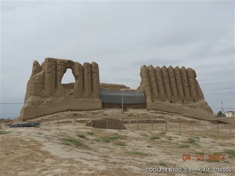
Great Kyz Kala at Ancient Merv
So, you have just seen the legendary Registan in Samarkand, then the incomparable Po-i-Kalyan Mosque complex in Bukhara - how do you follow that? With the truly astonishing site of Ancient Merv in Turkmenistan! What makes the place astonishing is its sheer scale and the breadth of monuments that reflect a sweep of history not seen anywhere else. On this single site you will find remnants of Ekr Kala (6th C BC) with its Citadel Gayur Kala (3rd C BC), Sultan Kala (8th-11th C AD), Abdullakhan Kala and Bairamalikhan Kala (15th C AD), the Mausoleum of Sultan Sanjar (12th C AD), Great Kyz Kala and Little Kyz Kala (6-7th C AD) and the Mausoleum of Muhammad inn Zeid (12th C AD).
If that sounds like a lot of Kalas it arises for two reasons:
* Merv was a rich area, right at the centre of the Silk Road and was conquered and reconquered time and time again, but new masters mostly built there own city close to the previous one and not on top of the existing
* The River Murghab which provided the water which made the area so fertile was constantly changing its course. Again this meant newcomers tended to build on new sites if the River course had shifted
See more pics of Ancient Merv
Tuesday 3rd October - crossing from Uzbekistan to Turkmenistan and a drive through the Karakum Desert to Mary
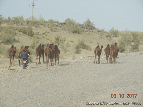
Camels being herded by motorcycle in the Karakum Desert
Onward! To our fourth country, Turkmenistan. Hands up those who had to get the map out to find it?? First, the small matter of the border crossing from Uzbekistan..... no good whinging, we all know what's involved and hey ho this is Adventure Travel! But to give you some idea it took us two hours to get out of Uzbekistan and another hour to get into Turkmenistan. Given there were only a couple of dozen travellers including our gang, you may be a bit puzzled. Well, our passports were checked - I think - six times by the Uzbeks and lots of waiting around between checks. All this taking place in the lunar landscape of the Karakum Desert and much of it out in the sun. Getting the picture?? Turkmen guys only checked the passport four times, I think, but made us open all our luggage and rifled through it. Having been well briefed in advance I left all my dirty laundry at the top!
Once through we had our 200 mile drive through the desert: lots of excitement when we saw our first wild camels, then a bunch of domesticated beasts being herded by a guy on a motorcycle. We can't entirely figure out why they are kept, we have never come across camel burgers......
See pics of Turkmenistan
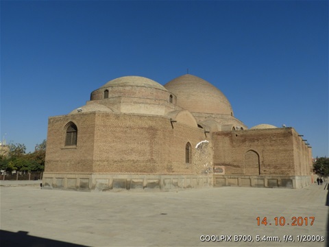
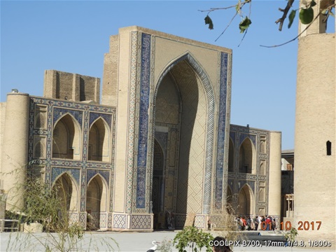
Monday 2nd October - Bukhara
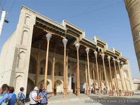
The lovely Bolo Hauz Mosque
We had a warm and busy day visiting the delights of Bukhara. There is little point comparing the city with Samarkand, but to me it seemed more intimate and its treasures more accessible than the vast complexes in the other city. Both were amazing!
One of the delights of Bukhara is that you can walk to pretty much everywhere and the city is very compact. We had no difficulty taking in the Ark Fortress, the Po-i Kalyan complex and the Bolo Hauz Mosque in a single day because there was no pressure to hop on and off the bus!
See more pics of Bukhara
See pics of Ark of Bukhara and its Friday Mosque
See more pics of Bolo Hauz Mosque
See pics of Po-i-Kalyan Complex
Sunday 1st October - Drive to Bukhara
Ulugbek Madrassa in Bukhara
Another interesting rather than spectacular drive, this time along the fertile valley of the Zeravshan River between Samarkand and Bukhara. The countryside was largely well cultivated, but with a great deal of cotton, manually harvested as always it seems in Uzbekistan. Pretty much every modern car on the road was a little white Chevrolet built in Uzbekstan.....
We enjoyed an excellent lunch at a roof top restaurant in Bukhara overlooking the ancient Bazaar and had our first browse around the city during the afternoon.
See more pics of Our drive from Samarkand to Bukhara and another Ulugh Beg Madrassa
Saturday 30th September - The Registan in Samarkand
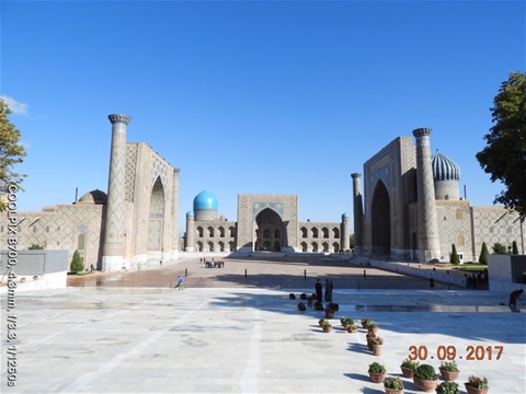
Classic view of the Registan in Samarkand
We got up Saturday morning very excited about the prospect of visiting the Registan, which we had seen briefly the previous evening. The whole place was almost overwhelming - it is beautifully laid out around the square, the architecture of the three madrasahs all stunning but each different and the weight of history was almost palpable. We were not disappointed!
See pics of The Registan in Samarkand
Having spend the morning at the Registan we got back on the bus to go visit Mirzo Ulugh Beg's Observatory. If i seem a little inconsistent in some of my spellings it is partly because eminent figures from history would often have three different names and always each of those names would have at least a couple of different spellings! I have tried to be consister, but i realize i have not always succeeded....
We went on to do the tour of the Old Samarkand Paper Factory where they have tried to faithfully reproduce the paper making process that was introduced to the city from along the Silk Road by the Chinese in the 7th Century. The Paper Makers of Samarkand proved to be very skilled and the paper was in demand throughout the Middle East and Central Asia.
See pics of Mirzo Ulughbeg's Observatory and Samarkand Paper Making
Friday 29th September - the Bullet Train from Tashkent to Samarkand; the Amir Temur Mausoleum and the Shah-i-Zinda Necropolis
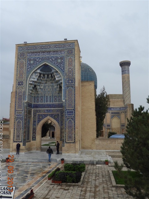
The entrance to the Amir Temur Mausoleum
Our second bullet train journey was much more comfortable than the first, not least because our guides had the foresight to arrange for our main luggage to be carried by coach overnight, instead of us having to lug it around..... the train left and arrived on time, topped 140 mph AND we were served a light breakfast as part of the deal! The scenery was interesting rather than spectacular: mainly rolling plains with varying degrees of fertility from low grade semi-desert used for grazing cattle, sheep, goats and horses to large cotton fields through to cereals, fruit and vegetables. However, despite having large resources of natural wealth - gold, copper, oil and gas: as well as a great deal of potentially productive agricultural assets Uzbekistan does give me the impression of being dirt poor. As we have already seen, its vast production of cotton is harvested manually and we saw lots of images redolent of Gone With The Wind of folks bent double in the fields picking cotton by hand. Still, HSBC is predicting Uzbekistan will be one of the fastest growing economies in the world (top 26) in future decades. Much of this is based on the assumption that the new president will continue to relax stringent government controls on the economy and encourage foreign investment.
See Pics of our journey Bullet train to Samarkand
Of course the country does have a remarkable heritage of history not least of which was its position at the heart of the Silk Road. Its Islamic Architecture is amongst the finest in the world and Samarkand is at the epicentre of that legacy. Our first exposure to this legacy was the Shah-i- Zinda Necropolis which was formed between the 11th and 19th Centuries and contains more than 20 buildings, many of them built to house the mortal remains of relatives of Amir Timur.
See pics of Shah i Zinda Necropolis
Timur who? Some of you may be thinking.... that would certainly have been my reaction until I started researching ahead of this trip! You might perhaps recognise him more easily by his alternative name of Tamerlane. Born in 1336 in Uzbekistan he was a Turco-Mongolian conqueror. He ruled over an empire that extended from southeastern Turkey, Syria, Iraq and Iran, through Central Asia encompassing part of Kazakhstan, Afghanistan, Armenia, Azerbaijan, Georgia, Turkmenistan, Uzbekistan, Kyrgyzstan and Pakistan. He approached Kashgar in China and captured Delhi in India in 1398. He died in 1405 while he was on his way to attack the Ming Dynasty in China. Although Timur's empire was relatively short lived, his grandson Babur went on to found the Islamic Mughal Empire which ruled over most of Afghanistan and North India. Babur's descendants expanded that empire to include most of the Indian subcontinent.
More about Amir Temur aka Tamerlane
Thursday 28th September - through the mountains from Kokand to Tashkent
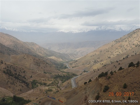
Road through the mountains between Kokand and Tashkent
Thursday morning saw us up at 5:00am to travel by car from Kokand to the capital of Uzbekistan, Tashkent. We have been used to travelling mostly by single deck coaches on this trip: excellent because we can spread ourselves around and everybody gets a window seat! So why travel in a convoy of five cars? The explanation was that the mountain road is too difficult for a coach..... that sounded promising!
They were not wrong about a coach, but this was not the kind of 10,000 feet deserted pass with 20,000 feet plus peaks we had experienced crossing the border between China and Kyrgyzstan.... this was to do with the enormous volume of traffic and the fact that the Uzbeks seem to be making a right meal of trying to re-develop the road!! Yes, there were some high passes and lots of zig zag roads up and down steep slopes, but the kind of modern coach we have been using could be expected to take such things in their stride. No, the road was simply a right battlefield because of the redevelopment and manic busy. So, we found ourselves in what seemed like some crazy Demolition Derby with the anarchic Central Asian driving we have come to know and love, to which was added the delights of travelling in a convoy comprising five Uzbek drivers! Of course we got there safely but five hours in the back seat of a tiny Uzbek built GM Chevrolet was not my idea of fun despite the many stretch and/or pee stops the guys kindly made. Scenery again was spectacular if not breathtaking and there was some spiteful fun watching what appeared to us to be the Uzbeks struggling to build their new road using antiquated construction techniques and bizarre traffic management. What a constrast with the Chinese way of doing things!!
Our Uzbek friends apologised for all the checkpoints along the road and they put it down to post-Soviet era bureaucracy and paranoia. Given it's now over 25 years since they got their independence that sounded a bit strange. Patience of course is the absolute requirement which we have learned pretty good. However, Special Forces guys with black face masks and toting sub-machine guns can still make even the most hardened traveller a mite nervous....
In marked contrast to the Fergana valley initially we seemed to be driving through yet another desert as we left Kokand, but we soon realised much of this 'desert' was in fact grazing land, but poor looking grazing land. This was reinforced for us by the herds of a couple of hundred sheep we ran into from time to time coming towards us on the wrong side of the dual carriageway! The land became more fertile as we got closer to Tashkent, with increasing heavy engineering and what looked like coal fired power stations
You can find some more pics of our journey and of Uzbekistan here:
Wednesday 27th September - Another slow border crossing into Uzbekistan and our drive through the Fergana Valley to Kokand
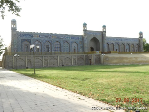
The Palace of Khudayer Khan in Kokand
Another early start to get to the border between Kyrgyzstan and Uzbekistan. As before Kyrgz were pretty easy going and getting out of their country was pretty straightforward. Getting into Uzbekistan was another matter, seemingly endless requests to produce our passports and a finger tip search of our baggage, looking for prescription and other drugs.
As always with patience and good humour we eventually found ourselves in our third country.
As we made our way along the road towards Kokand we saw the thousands and thousands of acres of cotton fields planted first by the Soviets when Uzbekistan was an SSR. We had expected that. What we did not expect was the sight of thousands of workers hand picking the cotton like a scene from Gone With The Wind. Our American fellows travellers assured us that it has been many decades since cotton was handpicked in the US fields . The other unanticipated outcome from the Soviet decision to grow cotton in this part of the world is that the crop requires huge amounts of water and the enormous irrigation projects that support cotton have been a major factor in the destruction of the Aral Sea.
We also had a little to visit a Silk Factory and i have included a few pics of that in the link below.
See Pics of The Palace of Khudayar Khan at Kokand
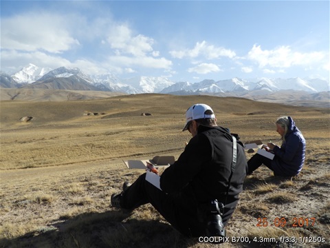
Tuesday 26th September - our drive from Sary Tash to Osh via the Fergana Valley
Early morning shot of the Trans Alay Mountains
Once again we found ourselves driving through truly spectacular scenery for the first half of our journey from Sary Tash to Osh. Maybe that contributed to making the second half drag a little but we had been on the road for many hours by the time we got to Osh.
We had a great leg-stretch when we did get to Osh by climbing up the few hundred feet high Soloman's Throne, which is described by UNESCO as 'the most complete example of a sacred mountain anywhere in Central Asia, worshipped over several millenia'.
See Pics of Our drive from Sary Tash to Osh
Monday 25th September - a tedious border crossing from China into Kyrgyzstan
A Picnic at 10000 feet having crossed into Kyrgyzstan
So, nobody wants to be accused of whinging, but how tedious was this, our first border crossing since entering China?? We had been carefully briefed by Jude our Tour Leader on what to expect and how to behave. No photographs, keep your voice down, no jokes or larking about...... We were very well behaved but considering all we wanted to do was to leave their country, the Chinese certainly managaed to make an Epic out of it. I think our Passports were checked seven times, our luggage searched and kept waiting seemingly endlessly to move from one stage to the next....Still, hey ho, this is Adventure Travel, so chill out and get on with it, which is what we did for three and a half hours from when they first looked at our Passports to when we finally trudged through the no mans' land into Kyrgyzstan!
What a relief to get to the Kyrgystan side where their checks were perfunctory presumably because they rely on the Chinese process!!
Absolutely stunning scenery all around and then a picnic on the Kryg side at 10,000 with amazing mountain views finally got us over it all......
Pics of Our drive across the mountains to Sary Tash
Generally i don't like posting videos on the blog because they are so greedy with memory. Given the stunning nature of the moutain vistas in this part of the world i have made an exception here and you can take a look at this video looking south from Sary Tash towaryd the Tajikistan border and the 23,406 feet high Lenin Peak: Kyrgyzstan Mountains and the Lenin Peak
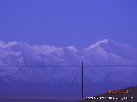
Sunday 24th September - Kashgar: Animal Market
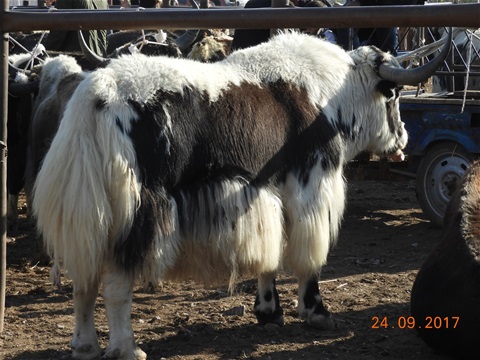
Healthy looking bull of local breed
Most of the tourist guides are clear that the two markets in Kashgar - the Livestock Market and the Bazaar - are definately not to be missed! So, we finished up with a pretty busy day: the Livestock Market first thing, off to have a look at the historic former British Consulate in Kashgar, the Kashgar Bazaar and then the Kashgar walled Old Town which has really only now begun to see some serious renovation work. Somehow we managed to squeeze in a delicious lunch in the middle of all that!!
Originally the two Kashgar Markets were both located where the Bazaar still is. However, the pressure on land space of development meant that the Livestock element was moved to a new location six kilometres southeast of Kashgar City: not least because of the smell!
See pics of Kashgar, including the Livestock Market
Saturday 23rd September - Xinjiang Autonomous Region Museum at Urumqi and the flight to Kashgar
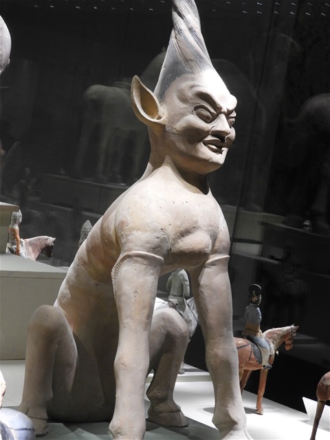
A female Tomb Guard c 14th Century
This adorable creature with a single boob and ears like mine own is a Tomb Guard attributed to the Tang Dynasty [618-907AD]. She was probably my favourite exhibit in a wonderful collection all beautifully presented.
Some of the most interesting sets of exhibits were those describing the clothing, traditions and lifestyles of the many ethnic minorities that live in Xinjiang the most westerly of all China's Provinces. 46% of the population is ethnic Uighurs who are Moslems. Next largest group are the Han Chinese 40% many of whom were originally shipped west by the PRC, allegedly with the specific intention of 'watering down' the ethnic dominance of the Moslem Uighurs. Other races include Kazakhs, Hui, Tajiks, Russians, Mongols, Han and Kyrgyzs: many of these minorities live in their own Autonomous Prefectures and Counties. Unfortunately my camera battery died and i was unable to capture any pics of this part of the Museum :((
More pics of Xinjiang Autonomous Region Museum at Urumqi
The flight on to Kashgar was smooth and incident free, but we had superb views over the snow capped mountains on the way across. I did manage to get a pic of that!
Friday 22nd September - Turpan: The Jiaohe Ruins and the Emin Minaret
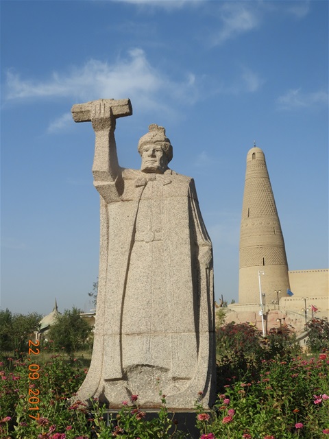
Statue of Emin Khoja in front of the Minaret which bears his name and is the tallest in China
Turpan was another important staging post along the Silk Road, in particular because it was where two of the main threads came together after having avoided the risks associated with driving straight through the desert.
Our first point of interest in Turpan was the Uyghur Mosqe and its famous Emin Minaret named for the Qing Dynasty General Emin Khoja who defeated the Dzunger Mongols in the 1750s. The minaret is 144 feet tall and is aid to be the tallest in China and was built in just 12 months of wood and sun dried yellow bricks. Both the mosque and the minaret have suffered earthquake damage as can be seen from the pics showing the steel band wrapped around the minaret. Although the Minaret is the major attraction here, primarily because of its height, the Mosque itself seemed to a model of understated beauty with its clean geometric lines and wonderful natural lighting There are no images or colour or distract the committed worshipper -in marked contrast to other Chinese Mosques and Temples and in particular Buddhist Temples.
See pics of Emin Minaret
The Jiaohe Ruins sometimes more theatrically named Lost City of Jiaohe sits on a large islet in the middle of a river in the Yarnez Valley a few miles west of the city of Turpan and is thought to date back some 2000 years. If you think about the Isle de la Citie in Paris, located in the middle of a desert you will not be far out! It is one of the few cities of its era that did not have a city wall. The steep clffs about 90 feet high on all sides were reckoned to be sufficient defence. Not against the Mongols of course and it was the city's destruction by Ghengis Khan that led to its abandonment in the 13th Century.
Today the ruins are a remarkable fragment of the history of the Silk Road: having been a thriving entrepôt with a population said to have been 7000 and located at an important crossroads for the Silk Road merchants and those who did business with them. The buildings were mostly carved out of the loess soil, with three substantial Buddhist Temples the walls of which remain today. The place has a ghostly, eerie air about it despite the scorching temperatures and is a truly dramatic place to visit.
See pics of The Jiaohe Ruins
Thursday 21st September - The Mogao Caves near Dunhuang and the Bullet Train to Turpan
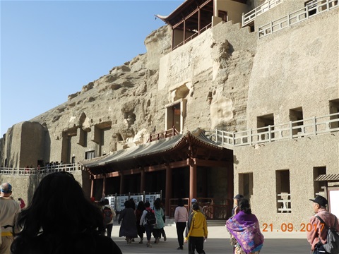
The Mogao Caves near Dunhuang
There are several Buddhist cave sites in the Dunhuang area but the most impressive and important of these are the Mogao Caves located 16 miles southeast of Dunhuang. There are 735 caves in Mogao noted not only for their Buddhist art but also for the hoard of vitally important manuscripts found hidden in a sealed up cave. Most of these caves are covered with murals and contain many Buddhist statues. Taken altogether the whole thing was pretty overpowering in terms of scale, numbers of statues and images and the beauty of much of the work, spanning over 1,000 years of Buddhist art. Photography is not allowed inside the caves so I am a bit limited in what I can show you in the pics.
See pics of Mogao Caves
For me what was very impressive was the organisation of the whole thing: there were two high quality film presentations before being whisked off on a shuttle bus to the caves themselves. The second 360 degree movie was particularly impressive and helped to compensate for the inability to take photographs. The murals and Buddha statues in the caves were brilliantly well lit and presented.
Some of our gang were disappointed by the apparent disneyfication at Mogao, as well as The Crescent Lake and less so at other places. However, with their gigantic domestic market, the desire of the PRC to make the history of the country as accessible as possible to all its people, the colossal amounts of money generated by these attractions and the well known appetite of the Chinese for all things Disney it is maybe not surprising!
The next element of our journey west was the Bullet Train from Dunhuang to Turpan. Unfortunately the PRC had a couple of nasty accidents with the Bullet Trains so for a while they were taken out of service. Now back on the rails their speeds are steadily being allowed to increase and we managed a little over 200 km an hour. The journey was spot on time and everything was very well managed but the accommodation was slightly more cramped than in Economy on Easyjet! Add to that all the stations are for some reason located in the middle of the desert and are a a bit short on escalators so the whole thing was not quite as congenial as we had expected!
This was another journey across a desert landscape, this time the Taklamaklan Desert. This seemed to me if anything even more desolate than the Gobi - covered in black sand and gravel with lots of rocky ridges which all made it clear why Silk Road travellers used to by pass it either to the north or the south with the two arms of the Silk Road coming together again at Turpan. We also saw thousands and thousands of wind farms, with endless newly constructed gigantic electricity pylons marching across the desert. And lots of huge construction projects with new motorways on stilts turning the One Belt One Road vision of China's paramount leader Xi Jinping into reality.
Wednesday 20th September - The Overhanging Wall at Jiayuguan and the Crescent Moon Lake at Dunhuang
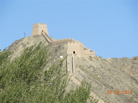
The Overhanging Wall at Jiayuguan
Our first really energetic day on the tour saw us walking up the Overhanging Wall part of The Great Wall so called because from a distance it supposedly appears like a dragon overhanging the slope. This part of the Wall is four miles to the northwest of the Jiyajuguan Fort and the climb is the equivalent of 55 flights of stairs made easier by the excellent views of the Gobi Desert and the glittering snowcapped peaks of the Qilian Mountains. All the members of our little team managed to complete the climb!!
Onward..... Driving for four hours through the Gobi desert to Dunhuang may not be your idea of fun, but trust me, it was fascinating! We had the snow topped Qilian Mountains (7800 metres) on our left and the more modest Black mountains on our right as we journeyed through the Hexi Corridor.
What was most amazing was the apparent determination of the PRC to grow stuff in the Gobi Desert! We saw many acres of very heavily irrigated farmland dotted around the vast expanse of the desert. What seemed more logical were the thousands of acres of wind farms and the miles and miles of giant new electric pylons carrying the power to places where it is more useful.
Dunhuang itself has a long history back as far as 2000 BC. More recently it became one of four frontier garrison towns established by the Emperor Wu after the defeat of the Xiongnu in 121 BC and was fought over many many times after that until it was sacked and destroyed by the Mongols in 1227 AD. Having prospered greatly from its advantageous position at the crossroads of the Silk Road it went into decline when the Silk Road was abandoned as the Southern sea-routes took over during the Ming Dynasty. It was retaken by China in 1715 during the Qing Dynasty and the present day city of Dunhuang was established east of the ruined old city in 1725.
See pics of The Overhanging Wall
We then made the obligatory visit to the highly touristic Crescent Lake and the Singing Dunes along with many thousands of others most of whom could not resist the opportunity to ride one of the several thousand camels available for the purpose: despite my cynicism there did seem to be a certain romance in trekking out into the desert on a camel a la Lawrence of Arabia. That said camels are in my experience nasty, smelly, bad tempered creatures which most of us had ridden before so we gave it a miss to the evident disappointment of our guide..... We didn't hear the reputed 'Singing Dunes' either - probably it was too noisy! Still, the dunes themselves were very impressive at up to 500 feet high and the much reduced Crescent Lake does still retain a certain charm.
See pics of Crescent Moon Lake
Tuesday 19th September - Jiayuguan and the The Great Wall
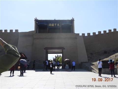
Eastern entry Gate to the Jiayuguan fort on The Great Wall of China
Modestly known in Chinese as 'The First and Greatest Pass Under Heaven' the fort at Jiayuguan is the largest and most complete structure still standing on the Great Wall. Construction started during the Ming Dynasty sometime about 1372. Much extended and strengthened over the years of the Silk Road the fort covers an area of 361,000 square feet and the external walls have a total length of 2400 feet and are 36 feet high. The fort guards a pass in the Hexi Corridor that is just 3.7 miles wide.
See pics of The Jiayuguan Fortress
In many ways there is an even more impressive artefacts of Ancient China near Jiayuguan: the 1400 or so tombs dating from the Wei and Jin Dynasties in the 3rd to 5th Centuries. The PRC has adopted a policy of protecting these sites and only a handful have been excavated and only one is open to the public. If you can imagine a small hillock of sand in the middle of the vast expanse of the Gobi Desert which has lieing beneath it something akin to a Pharoah's tomb in the Valleyof the Kings then you will not be far out. No photography is allowed in the tombs but I hope the pics provided will give you some idea of the magnificent colour sketches the tomb contains. A real treasure.
See pics of Wei and Jin Dynasty Tombs
Onward: driving for four hours through the Gobi desert may not be your idea of fun, but trust me, it was fascinating! We had the snow topped Qilian Mountains (7800 metres) on our left and the more modest Black mountains on our right as we journeyed through the Hexi Corridor.
What was most amazing was the apparent determination of the PRC to grow stuff in the Gobi Desert! We saw many acres of very heavily irrigated farmland dotted around the vast expanse of the desert. What seemed more logical were the thousands of acres of wind farms and the miles and miles of giant electric pylons carrying the power to places where it is more useful.
Monday 18th September - Xiahe to Jiayuguan via the Binglingsi Caves
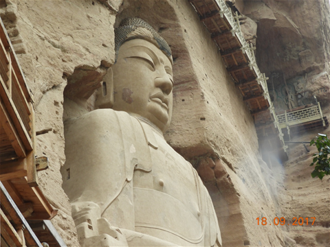
100 feet tall Maitreya Buddha at the Binglingsi Temple and caves on the banks of the Yellow River
Having spent two nights at about 10,000 feet in the Gannan Tibetan Autonomous Prefecture we headed off back to Lanzhou to pick up our second Sleeper Train to travel west to Jiayuguan the most westerly gate in the Great Wall of China.
Along the way we were lucky enough to fit in a visit to the Binglingsi Caves which are a series of grottoes carved into the rock in a canyon along the Yellow River just north of where it empties into the enormous Liujiaxia Reservoir.
The first of the grottoes was begun about 420 AD and the site can only be accessed via a 40 minute speedboat ride across the lake.
Have a look at the pics which include the Yellow River gorge: Binglingsi Caves
Sunday 17th September - Labrang Monastery
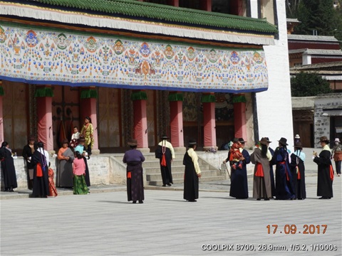
Tibetans in traditional dress outside Prayer Hall in Labrang Monastery complex
Labrang is one of the six most important monasteries of the Gelug (Yellow Hat) school of Tibetan Buddhism and the Monastery with the largest number of monks outside of the Tibet Autonomous Region (the PRC's name for the former country of Tibet). The Monastery is located in the Gannan Tibetan Autonomous Prefecture in Gansu Province about 700 miles north west of Tibet itself.
Despite lots of tourist activity Labrang retains the air of calm you would expect given its breathtaking location up in the mountains alongside the Daxia River a tributary of the Yellow River. Our experience was enhanced by the young monk who acted as our tour guide. His combination of gentle humour and unshakeable belief in his faith affected us all. If you had to spend your whole life in a single place Labrang would be a great choice!!
Click here for pics of Labrang Monastery
Saturday 16th September - X'ian to Labrang Monastery via Lanzhou
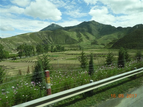
Everywhere we looked on our bus ride from Lanzhou to Lebrang we saw spectacular scenery and lots of wild flowers.
Our next adventure was a nine hour sleeper train journey from X'ian to Lanzhou about which a couple of pages could be written!! However, a straw poll suggwests average actual sleep time was a couple of hours.... I'm feeling pretty smug because my deafness contributed to a reasonable night's sleep for me!
Final part of our journey was a three hour bus ride to Xiahe through stupendous mountain scenery for our visit to the Labrang Monastery scheduled for Sunday. The actual journey time was longer because we stopped off in Linxia for a look at the Da Gongbei mosque, HQ of the Qadiriyyah school of Islam.
Xiahe is at about 10,000 feet, so lots of breathlessness after lugging bags up the stairs of our hotel!!!
For more pics of our journey: Lanzhou to Xiahe
Friday 15th September - The Terracotta Army
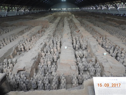
Row upon upon row of warriors charged with protecting the Emperor after his death
Qin Shi Huang was 13 years old when he ascended the throne and by the time he was 38 he had conquered all the other Warring States to unify China for the first time in 221 BC. As a result of his exploits became the First Emperor of China.
As soon as he ascended the throne at 13 years of age work was started on his mausoleum which over time evolved into a life sized Imperial Palace that he would inhabit after his death.
The Terraccotta Army at least 6,000 strong was created to guard him in that palace after his death. When he died prematurely in 210BC at the age of 50 the work was not complete but what we are left with is an awe inspiring testament to the wealth and power of his Empire.
It is also rather sad and ironic that Qin spent all his adult looking for the elixir of life that would make him immortal....
See more pics of The Terracotta Army
X'ian as a city is a great deal more than the stop off point for the Terracotta Warriors - it is a major cultural centre in it's own right with an astonishing city wall that befits its status as a former capital of China. The city wall was originally built in the 14th Century and is claimed to be the longest complete city wall in the world at eight and a half miles enclosing an area of 5.4 square miles and with a proper moat all the way round!
See more pics of Xian + its City Wall
Thursday 14th September - X'ian: Big Wild Goose Pagoda and the Great Mosque of X'ian

The Giant Wild Goose Pagoda in X'ian in Central China
X'ian is one of the ancient capitals of China and was founded by Qin Shi Huang Di the First Emperor, he of Terracotta Warriors fame. It was the start point of the ancient Silk Road which stretched all the way through Western China, Central Asia and the Middle East to the Mediterranean Sea.
The Big Wild Goose Pagoda was built in 652 by the Emperor Gaozong of the Tang Dynasty and originally had five stories. It was rebuilt by Empress Wu Zetian in 704 to ten stories, but an earthquake in 1556 reduced it to its current seven stories. Although at 210 feet tall it's a physically impressive building in itself the most rewarding parts of the Pagoda complex are the maps and manuscripts of the journeys of the Bhuddist translator and traveller Xuanzang. He became famous for his seventeen year overland journey around India during the 7th century. He returned to China and spent the rest of his life translating Indian Bhuddist texts into Chinese and vice versa. Xuanzang had a profound influence on the development of Bhuddism in China.
The Great Mosque of X'ian is the largest Mosque in China built in 742 during the early Ming Dynasty. It remains an active place of worship within the X'ian Muslim Quarter and now houses more than 20 buildings in its five courtyards and covers 130,000 square feet.
More pics of:
Wednesday 13th September - The Great Wall of China
Long day today: up at 5:00 for the 90 minute bus ride to Mutianyu for the first real energetic element of the trip: climbing up The Great Wall Then back to Beijing for our two hour flight to X'ian.
This very impressive section of the Great Wall is about 50 miles north of Beijing, built to defend the capital and the Imperial Tombs. It runs through spectacular and beautiful mountainous country thick with pristine green forest.
This section of the Wall was first built in the 6th Century during the Northern Qi but the present massive granite construction was created by the Ming Dynasty during the 14th Century.
Having worked up an appetite we then sat down to a gargantuan Peking Duck lunch before heading off to the airport. 90 minute delay for take off. So by the time we got to the rather splendid hotel in X'ian at 10:00 pm I just fell into bed and slept very soundly indeed......
See Pics here of The Great Wall at Mutianyu
Tuesday 12th September - Beijing: Tiananmen Square + The Forbidden City
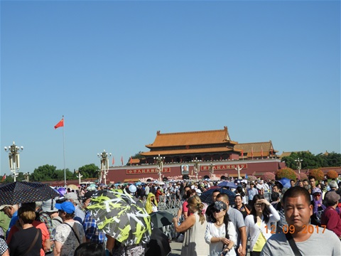
Mao's Mausoleum in Tiananmen Square
Epic crowds, of course, easily enough people to fill Wembley Stadium - probably twice over!!
It's not difficult to complain about that , but the crowds do simply reflect the profound historic importance of what we are privileged to witness: The Forbidden City with its several hundred palaces and temples as the manifestation of the greatness and sophistication of the Chinese Imperial Dynasties and Tiananman Square the focus of the Long March the Chinese people have made since 1909. It also reflects the enormous material and economic progress the country has made over the last couple of decades.
And for us simply the words 'Tiananmen Square' convey the reality that it has not been an easy journey and how much different their concept of democracy is from ours.....
More pics of Tiananmen Square and The Forbidden City
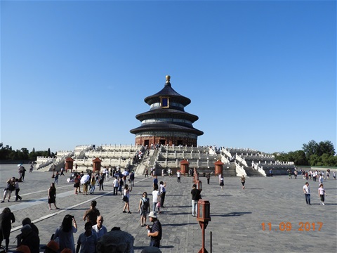
Monday 11th September - Beijing and the Temple of Heaven
Temple of Heaven, Beijing more accurately called The Hall of Prayer for Good Harvests
I borrowed one of the Hotel's push bikes this morning and went for a pedal around Beijing. Great fun provided you understand that traffic lights are regarded as purely advisory and folks ride and drive pretty much on whichever side of the road they fancy! What makes it work is that nobody actually wants to kill anybody else.....
The real reason for the excursion was that the Iranian officials don't like Men In Shorts and I realised when I unpacked today that I had not brought enough long trousers, so bought a couple of pairs at a local supermarket!! I knew there was a good reason why I always leave the packing to Margie!!!
Met up with the rest of the gang at lunchtime. Mostly Brits, a couple of Cousins, a lady from Fiji, two ladies from Oz and two folks from Switzerland. There followed a well behaved lunch but things livened up in a promising way over a slightly chaotic dinner.....
In between feeding we paid a visit to the super impressive early 15th Century Temple of Heaven. Built between 1406 and 1420 by the Yongle Emperor who was also responsible for the Forbidden City which we will see tomorrow. Much extended and refurbed over the years and much neglected after the downfall of the Qing, The Temple of Heaven complex is now all beautifully restored....
More pics of Beijing and the Temple of Heaven
Sunday 10th September - Hong Kong to Beijing
Another drama-free Cathy Pacific flight... Despite the frenetic pace of Hong Kong, it does all seem to work smoothly.
Can't say the same for Beijing: huge queue at immigration but never stopped moving. Long queue to get into the car park, even longer to get out. Beijing traffic lives up to its appalling reputation despite four concentric ring roads. No big deal, everybody very easing going, just allow plenty of time!!
Wifi and Internet a bit sporadic here at the mo', so the only pic I can provide for now is of our rather lovely and beautifully furnished hotel based in a converted hutong in the centre of Beijing. Chinese staff a little reserved at first and embarrassed if they don't speak English, but soon crack up and full of smiles and friendly helpfulness given any encouragement at all!
Saturday 9th September - Wan Chai and the Temples
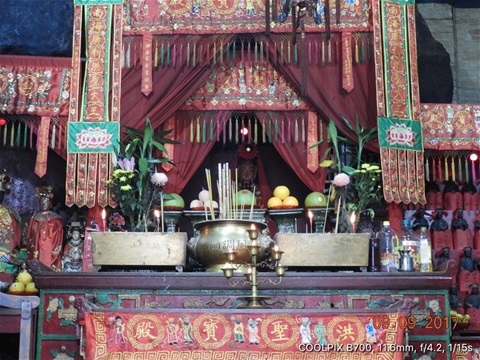
Altar @ Hung Shing (Tai Wong) Temple Wan Chai
Took the MTR this time from Kowloon across to Hong Kong Island and the district of Wan Chai east along Victoria Harbour from Central. If you are off to HK anytime soon I have an Octopus Card (like an Oyster Card) with HK$116 credit which it would be a shame to waste! First come, first served shout if you are interested.....
Wan Chai famous as the setting of the 1960 William Holding and Nancy Kwan movie 'The World of Suzie Wong'.... These days most of the girly bars are long gone and with all the reclamation of land from the harbour it's no longer a Waterfront destination.
A couple of great temples in Wan Chai if like me you are fascinated by such places. I won't bore those of you not much interested in such, but for those of you who would like to know more try www.ctc.org.hk for lots of detailed background.
For some more Temple pics and insights try More Pics of Hong Kong
Back to Kowloon on the MTR for another great meal of noodles and seafood, completely blown out for less than a tenner!
Friday 8th September - Hong Kong Island and The Peak
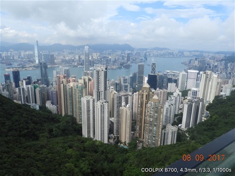
I ventured across Victoria Harbour to Hong Kong Island on the Star Ferry and joined the thousands of other tourists who take the Peak Railway to this legendary view point. This shot is probably what most folks associate with Hong Kong: huge skyscrapers on Hong Kong Island and Kowloon Side, separated by Victoria Harbour.
The tallest of all is actually on Kowloon side: the International Commerce Centre to the left of the pic stands 1,538 feet. On Hong Kong Island the tallest is Two International Finance Centre at 1,271 feet just left of centre on the pic. Both a lot taller than the Eiffel Tower (1,060 feet including the aerials!).
i guess it won't be long before they build one higher than Victoria Peak itself..... 1,820 feet!!!
More Pics of Hong Kong
Thursday 7th September - Kowloon, Hong Kong
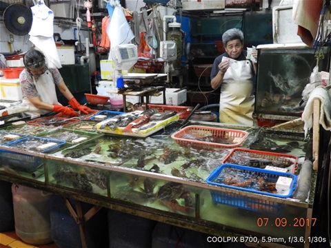
Live fish and seafood for sale @ the Night Market - comedian fishmonger showing me how much money he makes!
Spent most of the day ambling around Kowloon trying not to eat too much!! If food seems to be a recurring theme, you may be surprised but Margie and the kids will not be.... checking out the local cuisine always one of the highlights for me of travelling!
Wednesday 6th September: Heathrow to Hong Kong
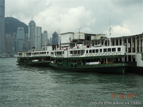
Star Ferries @ Kowloon with Hong Kong Island skyscrapers in the background
Not a lot to report: Cathay Pacific flight incident free. Gave us lunch immediately after take-off around 12:45, switched off the cabin lights @ 5:00 pm, then served us breakfast two hours before landing at 10:00 pm UK time!! My tum is pretty confused.....
Hong Kong airport a doddle compared to LHR and an interesting double decker bus ride across to Kowloon and my hotel: the Shamrock!!
See more pics of Hong Kong
David Riley
Hi Tony,
Just been catching up with the latter stages of your adventure - welcome home. How does it feel being back after such an amazing journey?
Tony
I'm tired, Dave! Thanks for the welcome home, happy to be back after an awesome experience that does not lend itself to a summary! Highly recommended if you have the time.... Best wishes, Tony
Tony
Ta, la - much appreciated! Pretty much up to date on last couple of days so working my way backwards to fill in some of the blanks..... XXX T
Margie
Hi T you have been working hard today, great pics xx
David Riley
Hi Tony, just been catching up on your adventure - it’s a terrific journey - I’m envious.
Tony
Really pleased you are finding it all interesting, Dave!! Doing my best to keep it up to date, but internet here in Iran very flakey... Turkey on Sunday, hopefully better! Best, Tony
Margie
Will keep checking!! Xx
Margie
Hi T, sounds like you found Merv almost overwhelming? One amazing sight/experience after another! Xxx
Jen
Hi dad, thought you'd find it funny to know that when Martha was being told off for being naughty this morning, she cried for grandad!!! Monkey! Bet you can picture it too xx
Tony
Hiya, Jen!! Thanks for this, just goes to show what a bad influence I am?? XXX Dad
Margie
All these buildings built to be as imposing as possible on everything around them it seems, really dramatic! Xx
Tony
Religions have always aimed to dominate the faithful, from the medieval village churches in rural that were built tall so that workers would see them each time they looked up!
Margie
Sounds like your journey today was not as bad as previous ones if a little tedious, hopefully no more special forces checkpoints. Have a good one xx
Tony
Ta, la!! XXX T
Mike
Your blog is becoming popular with clients!! No comments as yet but a few are following!
Tony
Thanks, Mike! Technology very flakey here in Uzbekistan... just spent 40 mins up dating and lost the connection!! Have two nights next in Samarkand so will do my best to get it more up to date Dad
Jen
Hey dad, how was the bullet train? Got everyone in the office following this now! Xx
Tony
Hiya, Jen! Thanks for this, hope I don't disappoint your colleagues - technology very flakey around here and I am now almost a week behind! Report on Bullet Train above on 21st September. XXX Dad
Margie
Will show a Fred the Fort when he gets back from football training, its huge!! Very intimidating even in a photo! Did you take any sunset photos? Xxxx
Tony
We left the Singing Dunes well before sunset, la, but I will see what I can do over the next few days!! XXX T
Jen
Hope you're still having a fab time pops!!! Xx
Tony
Just great, thanks, Jen!! Bullet train later today - excitement! XXX Dad
Margie
Difficult to get a real feel of the size of the Terracotta Army I would imagine unless you are there, but pretty amazing all the same!
Jen
Pictures are really good dad!! Hope you're having a blast - Marthas started stringing words together now and copying, literally, everything!! Fred's seems to be happy enough at big school. Much love x
Tony
Having a great time, thanks, Jen!! Love hearing about kids, well done Freddie on the writing... XXX Dad
Amir
Hi Tony, Sunday is Mike's Birthday, I just wanted to use your blog and congratulate to him from here. Happy birthday my friend I hope your special day will bring you lots of happiness, love and fun.
Tony
Always miss all of you, Jen, but this place is so frenetic you don't get a lot of time to think about it!! Sounds like Freddie smashed it.... Well played handsome!!! XXX Dad
Jen
Looks incredible pops!! Missing us yet? Think a certain little lady is missing you! Fred's had a fab first week at Garth. Much love xx